|
Precipitation prediction for Tokyo area by 3D nowcast (refreshed every 30-sec, 10-min forecasts, 30-sec interval, 2 km above mean sea level) Initial time: NOW LOADING...
Auto-refresh every 30 sec (disabled after 30 min)
Animation
|
 |
How to read the charts
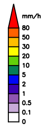
Colors represent precipitation intensity; colder colors for weak precipitation, walmer colors for heavier precipitation. Regions outside the forecast computation are indicated by light blue or gray. When the color is gray, the chart displays observations. When the color is light blue, the chart displays forecasts. The hatched areas in observation charts indicate that those areas are not covered by the radar. If real-time observations are not available, "No Forecast" will be displayed.
Past cases
See here for past cases.
Precipitation prediction for Tokyo area by 3D nowcast
The Data Assimilation Research Team is developing a 250-m mesh, 10-minute-lead precipitation forecasting system, based on the Multi-Parameter Phased Array Weather Radar (MP-PAWR) observations and the 3D nowcasting technique. The prediction is provided every 30 seconds in real time.
The observation data used in this forecast is provided by Multi-Parameter Phased Array Weather Radar (MP-PAWR) at Saitama University, developed by a research group lead by National Institute of Information and Communications Technology (NICT) in the Cross-ministerial Strategic Innovation Promotion Program (SIP) "Enhancement of Social Resiliency against Natural Disasters". The MP-PAWR is the dual-polarized version of the Phased Array Weather Radar (PAWR), developed by Toshiba, the University of Osaka, and NICT. The MP-PAWR scans the three dimensional atmospheric volume every 30 seconds, which is about 10 times more frequent than normal operational weather radars.
3D nowcast developed by RIKEN estimates motions of precipitation areas in the 3D space from past and present precipitation distributions, and predicts future precipitation distributions, based on MP-PAWR observations that are refreshed every 30 seconds.
Disclaimer
This website provides forecasts from an experimental precipitation prediction system that is under development by RIKEN. We acquired the weather forecasting license (License #204) from the Japan Meteorological Agency (JMA) for the area surrounding Japan defined by 0-60ºN and 100-180ºE.
Because the weather forecasts on this website are experimental, accuracy sufficient for the practical use and stable environment for dissemination are not guarranteed. Therefore, the forecasts on this website are not suited for decision making regarding user's safety and benefit.
Please note that the weather forecasts on this website can differ from weather forecasts provided by the JMA. Please give precedence to the latest warnings and advisories from the JMA.
Use of information or data from this website is undertaken at the user's own risk. RIKEN takes no responsibility for any direct or indirect damage that may arise through the use of this information or data. Any part or all of this website may be changed, deleted, or removed without notice.
All text, photographs, diagrams, and other materials on this website are copyrighted by RIKEN unless explicitly specified otherwise on the website. It is prohibited to use, reproduce, or modify any of the material without RIKEN's permission.
References
- Otsuka, S., G. Tuerhong, R. Kikuchi, Y. Kitano, Y. Taniguchi, J. J. Ruiz, S. Satoh, T. Ushio, and T. Miyoshi, 2016: Precipitation nowcasting with three-dimensional space-time extrapolation of dense and frequent phased-array weather radar observations. Wea. Forecasting, 31, 329-340.
- Otsuka, S., S. Kotsuki, and T. Miyoshi, 2016: Nowcasting with data assimilation: a case of Global Satellite Mapping of Precipitation. Wea. Forecasting, 31, 1409-1416.